
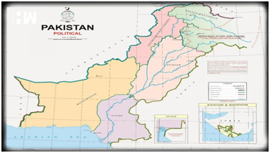
Pakistan government approved a new political map showing the union territories of Jammu and Kashmir, and Ladakh as Pakistani territories. The controversial map also shows the erstwhile state of Junagadh in Gujarat and Sir Creek within Pakistan’s borders. It also describes J&K as Indian Illegally Occupied Jammu & Kashmir. The Pakistani government confirmed that the map will henceforth be used in curriculum across the country.India has dismissed the map as an “exercise in absurdity” that made “untenable claims” to territories in India.

INFORM YOUR OPINION
- https://www.thehindu.com/news/national/the-hindu-explains-why-has-pakistan-prime-minister-imran-khan-announced-a-new-political-map/article32306669.ece
- https://www.thehindu.com/news/national/the-hindu-explains-why-has-pakistan-prime-minister-imran-khan-announced-a-new-political-map/article32306669.ece
- https://www.thehindu.com/opinion/editorial/cartographic-challenge-the-hindu-editorial-on-pakistans-new-map/article32289396.ece
- https://www.drishtiias.com/daily-updates/daily-news-analysis/pakistan-s-new-map
- https://indianexpress.com/article/explained/explained-when-junagadh-voted-to-join-india-and-pakistan-got-just-91-votes-6540331/


