
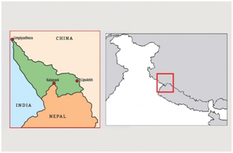
Nepal’s Cabinet has endorsed a new political map showing Lipulekh, Kalapani and Limpiyadhura under its territory, amidst a border dispute with India. The move announced by Foreign Minister Pradeep Kumar Gyawali came weeks after he said that efforts were on to resolve the border issue with India through diplomatic initiatives.
The Lipulekh pass is a far western point near Kalapani, a disputed border area between Nepal and India. Both India and Nepal claim Kalapani as an integral part of their territory – India as part of Uttarakhand’s Pithoragarh district and Nepal as part of Dharchula district.

INFORM YOUR OPINION
- https://www.hindustantimes.com/analysis/lipu-lekh-the-past-present-and-future-of-the-nepal-india-stand-off-analysis/story-wy3OvSD0G0nkxtGQTOIp2I.html
- https://indianexpress.com/article/explained/map-row-what-changed-in-india-nepal-ties-6470080/
- https://indianexpress.com/article/explained/the-new-indian-road-to-lipu-lekh-nepals-protests-and-the-strategic-importance-of-the-area-6413914/
- https://www.thehindu.com/opinion/lead/for-a-reset-in-india-nepal-relations/article31697691.ece
- https://indianexpress.com/article/opinion/columns/india-nepal-border-dispute-kalapani-lipulek-china-c-raja-mohan-6437884/


